Your Cart is Empty

Starring the lovely Ditte van der Meulen and Cherie Rusbatch, and following in their peddle strokes navigator Dave Mitchell and gun slinging Richard Western and their faithful steeds Norco, Yeti, Range and the Tallboy, with a limp.
If Molesworth Station was a country, it would be twice the size of Hong Kong and almost as large as Luxembourg. With a total population well below 100 humans, on a good day, and around ten thousand head of cattle, 80 horses and 45 dogs, sparsely populated would be an under statement. This was not always the case, having carried in its heyday fifty thousand sheep by intention and a rabbit plague by misfortune, before environmental collapse took hold back in the 1940s. The sheep and the rabbits competed vigorously for every skerrick of edible cellulose. Good farm management since then has seen the property thrive, and make room for recreation. It occupies a vast track of land behind Hanmer Springs bordering the St James Conservation Area and what was once the Clarence Reserve Station and is now called Ka Whata Tū o Rakihouia Conservation Park.

The Clarence Reserve Station is also massive. It straddles the seaward Kaikoura's for a breathtaking 40 kms and suffered from the same poor access and rabbits along with a harsh and very dry climate. In fact the access road from civilisation was blasted over Blind saddle and finally completed in 1969, but we were not dissuaded.
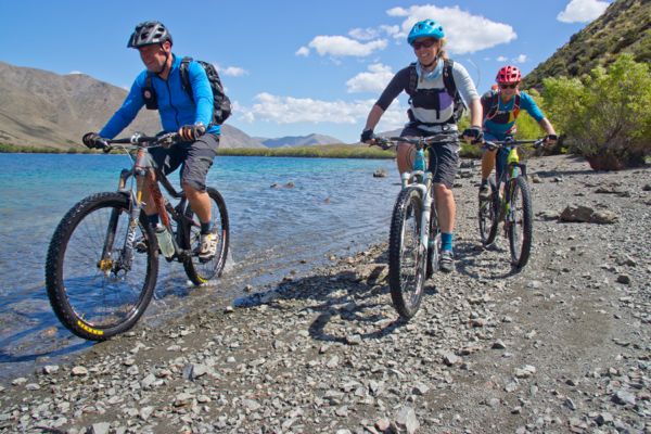
An activity permit from DOC is required to access the central zone of the station and was duly obtained. That fateful day dawned sunny and bright, as we lined up to ford the ankle deep Acheron River at the Guide River confluence. The weather forecast was bullet proof and the river gauge was recording the Clarence River at a poultry three cumecs. A well trodden farm 4WD track took us past the Guide Hut (station use only) and up the Guide River. The usual big black Angus cattle were absent from the lush valley flats. We had ridden but a few hundred meters when Richard's attempted front chain ring shift went bad. A broken derailleur was soon extracted from the clutches of a twisted chain and manual front shifting ensued from that day forth. He had been minding his Ps & Qs while dreaming about his salmon sausages and Vic's Bakery bagel stowed in his pack.
A short steep climb took us over a barren ridge away from the Guide River and into the Half Moon Stream. The 4WD track continued unabated to Half Moon Hut (station use only) where it all but ends. From there we picked up the old original dozer track, that once upon a time travelled unbroken to Lake McRae and beyond. Substantial sections still remain but joining up of the dots is still required where the river and slips have taken their toll.
Death by a thousand cuts. Our forefathers who introduced rosehip to these fair shores would surely go down in history as misguided, along with the aliens who bought humans to planet earth. At this point in the story I must mention the vast sea of scratchy and prickly rosehip and matagouri ahead of us, putting paid to our 2016 modeling career.

Where the Half Moon Stream joins the Dillon River we headed upstream and remembered from our previous trips (2004 and 2015), to ignore all side streams and keep a good eye on the map. The prominent north west face of Dillion Cone is plain to see amongst the barren scree ridges and foot hills of this dry and desolate but beautiful edge of the station. Rosehip and blue-borage rise up out of the hieracium but the river flats were green and lush. After a long gradual climb, we finally left the Dillon River, which by now has become no more than a trickle, making our way onto Carters Saddle and the highest point of the ride. By a couple of historic 44 gallon drums we lusted after Richard's bagel and his salmon sausage lunch, making do with lesser fair.

We descended from Carters Saddle over an old scree slip, then down the rough and ready dozer track to the Tweed River Valley. A large pocket of native bush seems to have survived pre 1950s burning practices, with totara, kanuka, lacebark and a bit of beech above a host of smaller species. Very little of the dozer track remains in the lower valley, but a great network of singletrack (cattle track) headed all the way to Lake McRae. We had a ball, criss-crossing the river and dodging rosehip and matagouri along the trail. Sharp rocks were another story though, and after an encounter with one, a vast quantity of frothy latex and air escaped from Richards tubeless front tyre, bringing proceedings to a grinding halt. An external tyre patch seemed to do the trick and got him back on the path to redemption. Girl scout Cherie miraculously produced a roll of black PVC electrical tape which was ideal to reinforce the patch, a small card of fuse wire in 5,10 & 15 amp increments that came with it, would have to wait for a different sort of crisis to unfold. Lake McRae Hut hides amongst a hedgerow of willows, just above a subterranean outlet from the lake itself. A great place to re-hydrate and fill up our water bottles to the brim. A row of working dog accommodation preceded the human equivalent, with their red lead corrugated tin roofs shining in the midday sun, they looked forlorn and were empty. The ghostly barks of musters past reverberated from their corrugated inner sanctum.
It might be called Lake McRae Hut but its no where near any water body. We parked our bikes and refueled in the cool calmness of the hut before embarking on the climb up to the lake. Richards tyre patch spectacularly failed at the top of the climb and we reluctantly inserted a tube after re-enforcing the flailing sidewall with a doubled up strip of duck, or is that duct, tape. Note to self, I will have to ask Guy to tell me yet again the origins of the name duck tape, but I am pretty sure no wild fowl were harmed in the making of Richards roll of said tape. On the other hand, station manager Jim would be quite pleased if the thousands of Canadian geese we noted munching prime pasture like rabbits would come to irreparable harm along with the wild pigs and smelly goats, but I digress.
Many moons ago two massive land slips formed the beautiful Lake McRae and around its edge we rode on hard shingle, where an impressive totara forest thrives. The lake is a little over a kilometer long and half as wide, it's electric blue waters looked very inviting to four hot and dusty mountain bikers. At the east end of the lake the dozer track continues up to a low saddle before dropping down to the Elliot Stream. The trick is not to follow this track initially but head north after the saddle and down the first ridge and back onto the old track. Thus avoiding a section of bush bashing that only Peter Plumly-Walker would have enjoyed, before being tossed over the Huka Falls.
The route down the Elliot Stream flats and along to the Elliot Biv, is now a well worn cattle track, and the biv is quite hard to find without a map and GPS. We did not go there but instead continued down the valley through swamp and over fallen willow for 1km to the first eastern side stream bed, ringed with willow trees and as dry as a wooden god. This is where the groveling and team work started. Vastly overgrown in the lower section but once we extracted ourselves from the prickly jungle it soon opened out into a wide clear-ish valley. It's home to families of bleating goats and pigs with their baby piglets in tow a squealing. The valley ultimately heads up to a low saddle topped by a lone marker, the first spotted so far on this trip.
We regrouped at the top and as Russ Taylor promised us, after tramping the route on foot, pure single track down to the Clarence River prevailed. Formed by horses and well marked it proved a blast at the end of a long hot day. Three slippery and warm Clarence River crossings of varying depth remained between us and the Forbes Hut, which was in the throws of a mid life identity crisis. From starting life as the Willows hut by the Willows Stream 20km up the river, then being dragged to its present location downstream of the Seymour Stream and re-named Seymour Hut, to finally being re-named Forbes Hut (just when it got use to that nomenclature), who could blame it. We crossed slowly but safely without drowning our kit and once ensconced in the previously empty hut headed back to the river to wash away the days sins. As the sun set in the west behind Dillion Cone the pots came out to play, water was boiled and a hearty feast was concocted and as quickly consumed. Ditte's plastic origami cup and bowl were the revelation of the evening produced as if by magic from a flat dutch orange coloured sheet of plastic. Supper was like an auto swap meet as the stars came out and drifted across the nights sky in stunning silence.


A fitful night sleep was had by all as the hut struggled to cool down, but morning came in a blaze of sunshine. We ate, packed and hut cleaned our way out the front door before heading along a wide 4WD track to the confused Seymour or Hearing Stream. It was a pleasure splashing our way up this water course surrounded by geologist heaven. Volcanic outcrops and the massive fingerprints of uplift and mountain building all around. We dropped into the historic Black Spur Hut, its timbers hewn from stands of willows in the 1920s. Warden hut was next to arrive with yet another historic hut, the restored Bluff Dump Hut adjacent. From these huts the climb to Blind saddle was plain to see on a track in perfect nick.


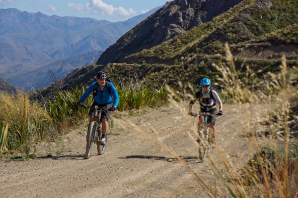
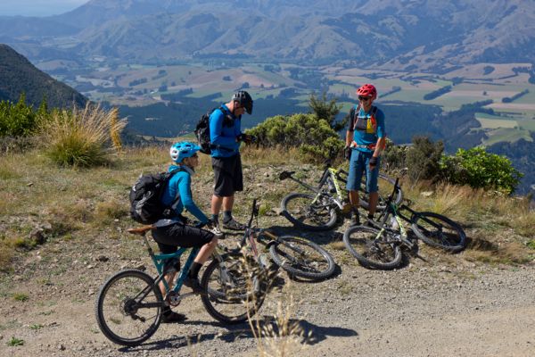
The last stream crossing provided a welcome refill before a long hot climb to the top. Its a lesser climb from this side by a few hundred meters and the gradient is more gradual. With lighter packs and the promise of an ice-cream along with Joe Arts and car waiting for us on the other side, we veritably flew up to the top. We had a pause to enjoy the commanding view back down into the Clarence River Valley and across the lumpy hinterland of Molesworth Station from which we came. The view down along the Kaikoura coast and out to sea was clear and blue and the descent was more of a plummet, with a couple of short uphill bumps along the way. We greeted our friend Joe at the bottom and hoisted our faithful steeds onto the roof rack. The ice-creams were huge, the trip back was a blur and our scratches diminished as the reality of the ride sunk in. Whats next I hear Richard, Cherie & Ditte say, less scratches please Mr. Yes we will see.
Distance:35km L.MaRae Hut, 18km Elliot Biv, 8km Forbes Hut, 28km Out to Kahutara carpark.
Grade: MTB moderate but requires good navigational skills.
Maps: BT26 Mt Clear, BT25 Mt Northampton
Access: DOC Permit required. www.doc.govt.nz & search Molesworth
Note: Keep to the track and leave all gates as you found them. Check ECAN river levels and only go on a good weather forecast. This area may be closed for safety reasons and farm management. Lake McRae Hut is 6 bunk, 1 ticket. Elliot Biv 2 bunk basic, Forbes & Warden Hut both 12 Bunk 1 ticket.