Your Cart is Empty

What do you do in the middle of the mountains when two large, thuggish Chinese men get out of a car and stride purposefully towards you? You smile and say thank you for the stale bread and peaches they are offering you! Never before on a cycle tour have I benefited from so much food and encouragement. Water, naan, watermelon and grapes were generously gifted. We were continually greeted with thumbs up and good wishes in words we could not understand. Once, while struggling into the howling wind and rain on the Tien Shan range, we hitched a lift on a truck - and then got to share dinner with the Uyghur driver and his crew. My enduring memory of the Xinjiang Region is the enthusiasm and warmth of welcome we received from the locals in each town.

At the other end of the emotive scale, we were often confronted with evidence of radical modification to the landscape. One billion people (give or take a hundred million or so) can muster seemingly limitless resources to change the environment at a speed that is difficult to comprehend. I heard an amusing story of a petroleum company that had surveyed an area for natural gas. When they returned less than a year later to drill an exploratory well, a power plant had been constructed on their proposed spot. An undeniable lack of communication, but no one can doubt the speed at which development occurs.

The contrast was perplexing. We cycled for 10 days through stunning glaciated mountains, high grasslands, wooded hills with raging rivers, and broad fertile alluvial valleys. This natural beauty was juxtaposed with the discovery of chemical plants built amidst peach trees, rivers dammed for electricity, yet more power stations on the plains, and tonnes of rubbish - plastic bags, bottles and paper tissues scattered near and far.

We cycled from Urumqi, the capital of Xinjiang, west to Yining on the Kazakhstan border. The route was around 700km and included one 4000m pass and a couple at 3000m. The Xinjiang Uyghur Autonomous Region is China's western-most province. 'Autonomous' somewhat belies the reality, which is centralised control from Beijing. Xinjiang is rich in mineral and energy resources (I was there surveying the northern deserts for gas), and so is a strategically important part of the modern Chinese Empire. It's remote and not overly touristed. The only other Westerners we stumbled across were showcasing their wares at the China-Eurasia Expo.
From Urumqi our route headed south to the Tien Shan mountains. A substantial height gain from 650m on the desert plain to 4500m in the mountains. Escaping the city necessitated negotiating the traffic and fumes commensurate with a population of 2 million. In their childhood the owners of these cars would never have dreamt of driving a motor vehicle. Bicycles were the dominant form of transport until only recently. 100km later and 1000m higher we found a campsite near a pretty river.

Accommodation options in Xinjiang read like a riddle. It is problematic for foreigners to stay anywhere other than the accredited hotels in large towns and cities. Challenging on a cycle tour. However you're ok in the smaller towns if you don't appear to be planning to stay there. We always acted like we were about to leave - bicycle loaded and heading onward. So, bear with me, if you don't stay in hotels you can trick the system and cycle around Xinjiang. But if you stay at a hotel where you ought not to be, you'll be 'deported' by bus or taxi to the nearest large town. Confused? We camped from Urumqi to Yining and never had our legitimacy challenged.

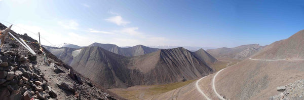
The following two days took us slowly over the 4280m Shengli Daban (Victory Pass) and down the other side. The gravel road had relatively little traffic. The scenery spectacular - with gorges, glaciers and high peaks. We then deliberated... another day to reach the southern side of the Tien Shan, or head west, taking the high road towards Kazakhstan for several more days. The high road won and we climbed back to the high grasslands. Day 5 found us negotiating another high pass as the wind got angry and the sky ominously turned from blue to grey to black.

The area is supposedly very similar to the Tibetan Plateau. I have wanted to travel there for a while, but now I'm not so sure. Our trucker rescue came towards the end of the gruelling fifth day, as we fruitlessly searched for a campsite in the extreme conditions. The exposed plateau was devoid of trees, structures or shelter of any sort. There was no water, other than that flowing in the gutter beside the gravel road. The truck evacuated us to a much lower altitude, and a paddock that we gratefully shared with a few goats.
The next morning we backtracked to the wooded hills dotted with gers to check what we had missed during our stormy descent. Xinjiang has a diverse and rich culture with its inhabitants originating from different neighbouring regions. We took tea (and more stale bread) in a Kazakh house luxuriously lined with deep-red rugs. An endearing local custom is to provide travellers with tea and bread to help them through the inhospitable landscape.

The last three days on tour was wonderfully relaxed as we cycled through the Yili Valley to Yining. A wide range of fruit and vegetables enhanced our diet, which had become rather bland in the mountains. Yili grapes and melons are famous throughout China. Stopping at local markets, we feasted on delicious meat and vegetable kebabs. Well fed, our arrival at Yining coincided with a final moment of concern. On the motorway, 5km from the city centre, we were beckoned into the police station. What now, should we not be cycling on the motorway? It turned out that a photograph of our passports was all that was required. Then we were invited to share breakfast... salty tea and somewhat predictably, stale bread.
